
TEST BLOG
Pre/Cap
Stratospheric Mind: A WWI Veteran & Old School Remote Sensing
It’s known as the overview effect, Re/Cappers. It’s a deeply reflective state, often experienced by astronauts when they look down at that precious celestial orb we call home, from far above it.
Now the thing about space is, 1) no one can hear you scream (IYKYK), because 2) it be MAD dangerous. That’s why strides like our lead, LiDAR-laden Re/Cap are so enthralling. It’s about earth observation & capture. High-res 3D mapping. Advanced payloads. Remote sensing.
But if Earth is the center of the universe, one veteran was the center of observing it, through surveys, overlapping imagery, and implacable curiosity. Meet U.S. Army Captain Albert W. Stevens, 1886-1949, a Maine-born engineer turned Army Air Corps innovator who embodied the audacious spirit of early aerial capture.
His remote genesis was the fog and fury of World War I, where he wielded oblique aerial shots and infrared-sensitive film to pull order from chaos. Stevens doubtfully knew it at the time, but his overlapping ways in aerial photography were advancing photogrammetry and remote sensing decades before the terms became mainstays.
To think Stevens would be sated with mere perspective would have been laughable; he wanted the horizon behind the horizon. After The Great War, peacetime offered no pause. He conducted aerial photography surveys of the U.S. throughout the ‘20s. Then, from low-orbiting biplanes, he leapt to the stratosphere in search of new views, new truths…and gave us all a new meaning of Earth observation.
1930. The Great Depression has humanity in a vice grip, leaving it thirsting for anything resembling delight. Stevens, aloft over Argentina, captured the first photograph to show the curvature of the Earth. Two years later, he snapped the Moon’s shadow racing across the Earth during a solar eclipse. Then, this d-airdevil aerially mapped Maine, and snapped a single photograph from 23,000 feet that captured Mt. Shasta from 331 miles away, encompassing 7,200 square miles in a single, stunning negative.
Next was equal parts science/spectacle/Evel Knievel. Twice in the mid-1930s, Stevens and his Army colleagues ascended into the thin blue via sealed balloons, Explorer I and Explorer II. This excursion was sponsored by the National Geographic Society and watched breathlessly by a public increasingly enchanted by skyward ambition. The first flight ended in disaster-tinged drama, the gondola plummeting nearly 15 miles after the balloon ruptured; all three men parachuted to safety, their exploits front-page news. Not to be deterred, Stevens returned the following year, crewing Explorer II with Captain Orvil Anderson. Together, they soared to a record 72,395 feet, snapping photographs that for the first time revealed the boundary between the troposphere and the stratosphere.
Stevens was not Earth observation’s inventor, per se. But the good Captain darn sure helped industrialize it. While photogrammetry technically existed decades before his Maine boots touched a balloon basket, Stevens parlayed fragmented imaging into systematic doctrine. His overlapping aerial surveys were the methodological DNA that would permeate every subsequent Earth observation mission. His stratospheric boundary documentation was remote sensing in its purest form.
Stevens died in 1949, 23 years before the multispectral scanner-wielding Landsat 1. Every LiDAR pulse, advanced payload, and hyperspectral scan of Earth's changing surface carries forward the systematic rigor he pioneered.
He captured the Earth, sure. But most vitally, he taught us how to see it. And today, as we’ll soon cover, we’re still broadening his horizons…in 3D.
Be clear, be confident and don’t overthink it. The beauty of your story is that it’s going to continue to evolve and your site can evolve with it. Your goal should be to make it feel right for right now. Later will take care of itself. It always does.
It all begins with an idea. Maybe you want to launch a business. Maybe you want to turn a hobby into something more. Or maybe you have a creative project to share with the world. Whatever it is, the way you tell your story online can make all the difference.
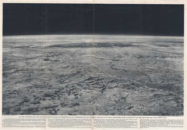
1936’s view from the highest point above Earth ever recorded. Image credit National Geographic viaGeographicus

Don’t worry about sounding professional. Sound like you. There are over 1.5 billion websites out there, but your story is what’s going to separate this one from the rest. If you read the words back and don’t hear your own voice in your head, that’s a good sign you still have more work to do.
Be clear, be confident and don’t overthink it. The beauty of your story is that it’s going to continue to evolve and your site can evolve with it. Your goal should be to make it feel right for right now. Later will take care of itself. It always does.
“Whatever it is, the way you tell your story online can make all the difference.”