


Plug those nostrils Re/Cappers, today we venture to the domain of Ninja Turtles and wastewater analysis - sewers, where drones are thriving as inspectors.
It is a reformative development for maintenance efficiency and human welfare; but the roots of drones for hazardous inspection go back further than the post-Thanksgiving queue for plumbers.
Like, 1946-further, when the United States conducted a seminal stride in nuclear testing, drone tech, and perilous data collection: Operation Crossroads in the Bikini Atoll, part of the Marshall Islands (+- halfway between Hawaii and The Philippines).
So it starts with two nuclear detonations, "Able" (an air drop) and "Baker" (an underwater explosion), aimed at studying the effects of atomic bombs on warships. This required rigorous inspection and data gathering in areas rendered lethally radioactive by the blasts.
For the first time, the U.S. military used remotely piloted aircraft *coughdronescough* for 1) inspection, 2) sampling in a nuclear test environment. These drones included the Boeing B-17 Flying Fortresses, and Grumman F6F Hellcat fighters, both converted into radio-controlled drones equipped with automatic cameras, radiation detectors, and air sample collectors. Pilots flew the drones from "mother planes" at a safe distance using radio controls, a significant feat considering the dang credit card hadn’t even yet been invented.
Minutes after each detonation, the drones flew directly into the mushroom cloud at various altitudes, collecting air samples and photographic evidence of the radioactive environment. No manned aircraft entered the central blast zone (Zeropoint) until hours after detonation, underscoring the drones' critical role in early, high-risk inspection.
The drones returned with precious data: air samples for radiological analysis and thousands of photographs documenting blast effects and radioactive phenomena. Operation Crossroads mobilized 42,000 personnel, 242 ships, 156 airplanes, and 750 cameras, but it was the drones that ventured first and deepest into the radioactive aftermath.
This set a precedent for using unmanned systems to inspect hazardous sites, be they nuclear, chemical, disaster zones, or your neighbor’s smoker going haywire. Such utility was foreseen by physicist William Shurcliff, who wrote in the official report Bombs at Bikini, that the operation was a “unique and impressive feat” that significantly advanced the science of drone operations. More specifically, Operation Crossroads’ pioneering missions of B-17 and F6F drones at Bikini Atoll were watershed moments for inspection…sans humans.
This evolution, from mushroom clouds to murky depths, reflects our paradoxical relationship with technology; creating solutions for problems we, in our unceasing quest for quality of life, engineered. The drones that once plunged into radioactive clouds now descend into our sewers, a fitting metaphor for how innovation can flow from military might to civic necessity.
As above, so below. Drone sewer coverage, coming right up.

The controller of an F6F Hellcat aboard the USS Shangri-La. Image credit “Operation Crossroads: The Official Pictorial Report.” via The Center for the Study of the Drone at Bard College
Fraser, Michigan didn’t deserve coal for 2016’s Christmas, but it sure got some. $75 million of it to be precise, after a December 24, 11-foot diameter sewer debacle 70 feet deep. A literal sinkhole of expense.
Though far from a rarity, its magnitude and price tag instantiated inspection importance far and wide, which can detect the ever-common cracks that can lead to pipe collapse. But traditional methods for our aging sewersphere (tethered cameras or in-person checks) are slow, expensive, and dangerous in such dark and confined spaces.
Y’know, the very environments specialized drones can thrive in - and are - in Fraser’s Macomb County and beyond.

Flyability’s Elios 3, a popular sewer drone. Number 1 or 2 for sure. Image credit Flyability
Rocking LiDAR, 4K cameras, gas sensors and ultrasonic thickness gauges, Fraser’s drone fleet is literally winning awards for its payloads & AI-driven inspection prowess, as relayed by Wired magazine.
Proving that the future of sewer maintenance is autonomous, fast, and disaster-proof, it navigates pipes to capture pristine data while avoiding human entry. Then, ultimate cut-the-crap software program SewerAI analyzes footage to automatically detect defects, slashing inspection time from months to 24 hours and reducing costs by 90% (e.g., $100k vs. $1M every 3 years).
Inspections now cover 900 meters per day (vs. 400m manually) with 40% cost savings, while capturing not only video but LiDAR, infrared scans, and gas readings. AI catches defects humans often miss, prioritizing critical repairs to prevent sinkholes. Inspect Wired’s link below for additional chronicling of Macomb County’s initiatives, drone manufacturers, pilot profiles and tactics, more figures & data, and the inspection steps.
Imagine if Lewis Carroll’s White Rabbit didn’t lead Alice to Wonderland, but built it on the fly, conjuring mushroom forests where the rules of physics were more guidelines than laws.
Our world has such bunnies, right now, sprinting ahead of reality with a pocket watch in one hand and a neural net in the other. As presented in a new piece by the tech & venture capital behemoth Andreessen Horowitz, they’re drafting blueprints for entire universes where architects walk through walls that don’t exist yet, gamers battle dragons that remember their last defeat, and filmmakers stage scenes where the audience becomes the protagonist.

Fei-Fei Li, Co-founder/CEO of World Labs and World Model builder extraordinaire! Image credit TED
The substrate of authors Colin Campbell and Jonathan Lai’s write-up is the infamous Star Trek Holodeck, a “persistent virtual universe” that’s dynamic, alive. And according to them, it’s close. Which is meaningful, considering Andreessen Horowitz has become a Babe Ruth of VC thanks to a bewildering track record of knowing what’s coming.
Our real-world holodeck is what they call “World Models,” an AI model that crafts virtual environments drawn directly from the physical realm. They claim that what ChatGPT is to text or Midjourney is to images, world models are to spaces.
Through two distinct approaches - native 3D world models and video-based - architects, roboticists, urban planners, game developers, and film studios are but a sampler platter of the trades that can augment their work through this burgeoning digital development. AI learned to Talk, Now it’s Learning to Build Reality is a sprawling read, but beyond worth it, sifting through Gaussian splatting, Google’s Genie 2, World Labs, knowledge out & creativity in, interface building, and economics.
George Washington said “Agriculture is the most healthful, most useful, and most noble employment of man.”
Little did the Father of His Country know it might also become one of the more laser-guided!
And because 72% of farms are smaller than 2.5 acres (~ 1 hectare), we’re not talking sprawling, GPS-guzzling mega-ranches. We're talking about the humble greenhouse, the high-bed strawberry patch, the kind of place where raised beds leave no room for error.
Those places are the benefactors of Assistant Professor Takuya Fujinaga at Osaka Metropolitan University’s compact bot. This plucker maps its world in 3D and glides between crop rows with the confidence of a surveyor and the agility of a ballet dancer.

Small-scale ag, large-scale idea. Image credit Osaka Metropolitan University via ZME Science
At its core is LiDAR, spitting out pulses, soaking up returns, and turning even the most chaotic greenhouse layouts into usable, up-to-date spatial data. Think mobile mapping, but scaled down and dirt-ready. The robot’s dual-mode navigation system combines waypoint guidance (basic go-here-then-there) with something far cooler: real-time bed navigation. By continuously scanning the edges of raised beds, the robot keeps itself centered and on course, regardless of how much the environment shifts.
By skipping the GPS and neural nets, this LiDAR bot asks: what if farming tools were just... smart enough? What if spatial awareness alone, when done right, could power the next ag revolution?
Till your way through the ZME Science article below, sprouting knowledge on plastic mulch drifting, row spacing, spatial model building, traditional ag bots’ woes, shortcomings of GPS dependence, labor crunches & production costs, and more.
Somewhere in a dusty server room beneath Mount Construction, a glowing USB stick was inserted…and suddenly, the jobsite evolved. April didn’t bring flowers - it brought products and power-ups, and Construction Dive overviewed the picks of the litter.
Think of them like a Match.com for preconstruction, a staunch opposition to delays and rework, a mobile scanner that’s always on the road again, and a Redwood Forest-sized collection of timber building design tools.
Here be the broad strokes of what just leveled up:
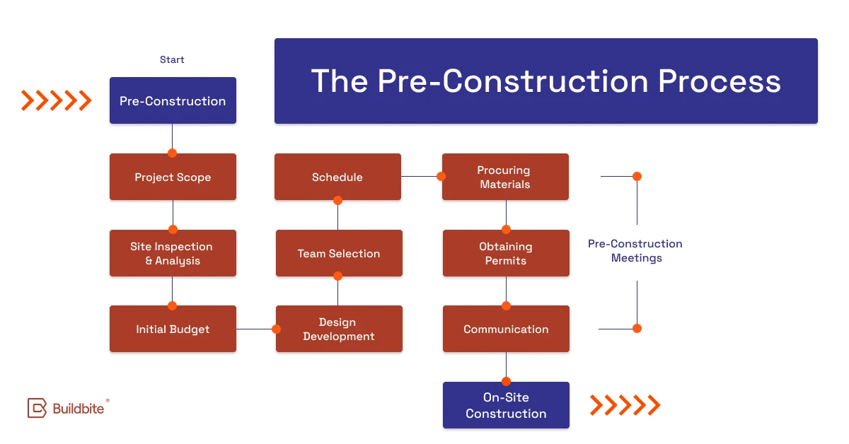
PreCon, one domain shown some tech love this past month. Image credit Buildbite
PlanHub’s version 2.0 of its project discovery, bidding and preconstruction software as an all-in-one platform that helps users connect with over 50,000 general contractors and manage projects efficiently. “2025 will be the year of construction tech-stack consolidation,” said Ro Bhatia, PlanHub CEO.
XYZ Reality enhanced its construction delivery platform with real-time data management, visualization tools, and automated reporting to help prevent delays and costly rework. The updated XYZ Platform features 360° site captures linked to 4D BIM models, granular tracking of up to 95% of construction activities, and dynamic status updates that reflect onsite progress in real time.
Topcon Positioning Systems expanded its road construction offerings with an upgraded RD-M2 mobile LiDAR scanner boasting enhanced satellite tracking capabilities. It’s a part of the SmoothRide solution designed to minimize road closures and optimize surface evaluation processes. EVP Murray Lodge highlighted the industry's need for innovation to address contractors' decreasing margins and cities' infrastructure challenges. TPS also introduced expanded aftermarket solutions for pavers and a new roller management system for soil compactors and asphalt rollers, which uses real-time data and automation to optimize compaction processes and includes a wireless Android display with interchangeable positioning sensors that can be customized with additional temperature sensors and accelerometers.
Australian startup CLT Toolbox launched its beta program in the U.S. and Canada, offering structural engineers access to its suite of timber building design tools that includes calculators for cross-laminated timber panels, connections, and fire safety requirements. The platform, which has gained over 3,500 users worldwide since its Australian launch in late 2023, is partnering with North American engineers and timber suppliers to customize the software for regional needs. Having secured $1.6 million in venture funding and built a team of 44 experts, CLT Toolbox plans a full North American rollout later this year following the current beta phase.
Full deets on each construction metamorphosis, below.

The Hartford Civic Center Roof, Connecticut, 1978. Image credit Connecticut Historical Society
In the predawn hours of January 18, 1978, Hartford’s Civic Center roof - a 1,400-ton “space truss” with the largest single span of roof ever lifted into place as a complete unit, and that architects hoped could defy convention - defied physics instead. At 4:19 a.m., the roof’s center plunged 83 feet onto 10,000 empty seats, leaving the arena floor buried under steel and snow. Six hours earlier, 4,746 fans had left a UConn basketball game unharmed, proving that even structural failures can have impeccable - nay, compassionate! - comedic timing.
Planned in 1970 as part of Hartford’s urban renewal push, the Civic Center’s roof was a digital guinea pig. Engineers used early CAD software to design a “space truss” of horizontal steel bars and diagonal beams, layered into a lattice meant to span 2.5 acres on just four pylons. The design promised cost savings and unobstructed views, but it also harbored fatal flaws. Steel members were arranged in a cross-shaped pattern, optimized for easy connections but weaker against bending and torsion than I-beams or tubes. Slenderness ratios of the steel members exceeded AISC standards, and bolt holes reduced critical tension areas beyond code limits. After adjusting the roof’s pitch for drainage, engineers didn’t update load calculations, leaving exterior braces overloaded by up to 852%. That’s like, tariff territory!
The roof began failing the day it was installed. Photographs taken during construction showed visible bowing in top-layer members-a red flag waved and ignored. Over three years, the truss sagged under its own weight, accumulating stress like a procrastinator’s inbox. Diagonal members near the pylons, critical for bracing, were misplaced, leaving the structure vulnerable to torsional buckling. By January 17, 1978, a snowstorm pummelled the roof, but the real culprit was already baked in. The top-layer members, weakened by poor bracing and cruciform geometry, approached their torsional buckling limit, and the center of the roof surrendered.
The collapse was eerily considerate. Maintenance crews, typically present overnight, were absent due to a scheduling quirk. The roof waited until after the UConn game, sparing thousands. Only two staff members were on-site, both far from the collapse zone. Investigators later called it a “progressive failure”, a term for when a structure politely disassembles itself one bad decision at a time.
The aftermath saw swift accountability and reform. Investigators identified critical design flaws, including cruciform members prone to buckling and inadequate bracing. The roof was rebuilt in 1980 using a conventional railroad-truss design-a humbler, code-compliant structure that still stands today as the XL Center, hosting hockey games and concerts with a healthy roof as a permanent attendee.
Had today’s reality capture tools existed, the Hartford Civic Center’s roof collapse might’ve remained a drafting error, not a full-scale catastrophe. High-res laser scans could have caught millimeter-level deformations in compression members during construction, feeding a digital twin capable of simulating snow loads. Clash detection tools could have flagged bolt holes compromising tension zones, while Building Information Modeling would have meant Building’s Roof Thriving.
3D models from drones equipped with LiDAR, photogrammetry, and 360° imaging could have enabled immersive inspections of the roof lattice, revealing stress points long before gravity took notice. Metrology tools would have validated steel alignment with surgical precision, catching bolt and beam deviations before they became structural liabilities. AI-guided robots could’ve crawled the frame, scanning for micro-cracks and corrosion with all the enthusiasm of tenured pessimists.
Automated point cloud–to–CAD comparisons could have flagged structural drift early, comparing as-built geometry to the original design. Thermal imaging might have revealed internal stresses or trapped moisture. And embedded structural health monitoring systems could have tracked strain and fatigue over time - like Fitbits for infrastructure, only less judgmental.
The Hartford collapse reminds us that engineering is as much about humility as it is about innovation. In a field where millimeters matter and assumptions compound, technology can catch what human confidence overlooks - but only if we bother to change.


By subscribing, you are agreeing to RCN’s Terms and Conditions of Use. To learn how RCN collects, uses, shares, and protects your personal data, please see RCN’s Privacy Policy.
Reality Capture Network • Copyright 2025 • All rights reserved


