


Lace up those walkin’ shoes Re/Cappers. Today, we’re strolling down sidewalks for a municipal use case that brings robots and surveying closer together than that Coldplay concert kiss cam couple.
It’s incidentally timely, too, as we approach the ten-year anniversary of perhaps the most intrepid, early instance of a city turning to robots (and drones) for infrastructural strength…and an ambitious 35-year vision.
It’s the fall of 2015, in the North of England. The potholed roads and flickering streetlights of Leeds may look ordinary, but just beneath them lies a technological shift, one that quietly foreshadows today’s automation wave. Leeds, in collaboration with its eponymous university and those of Southampton, and Birmingham, embarked on the multi-million-pound Self-Repairing Cities project, a national-first effort to move city maintenance from reactive repairs to relentless, autonomous prevention.
The spark: persistent infrastructure headaches - burst utility pipes, football pitch-sized potholes, aging water infrastructure, air pollution, and painstaking repairs that closed streets for longer periods than royal wedding news coverage. Rethinking the grind, the School of Civil Engineering secured £4.2 million in UK government funding to create a new generation of infrastructure caretakers - robots and drones, designed and built by the university’s engineers and trialed with support from Leeds City Council and UKCRIC (UK Collaboration for Research in Infrastructure and Cities).
Three clusters of autonomous machines would form this digital public works department. “Fire and Forget” robots, engineered to patrol utility pipes, could inspect, monitor, and mend corrosion or micro-failures months - or even years - before any surface leak. Above ground, “Perch and Repair” drones would perch on lamp columns and elevated fixtures, handling streetlight repairs and signage patch-ups without lane closures, or risk to human crews. On the streets themselves, “Perceive and Patch” mobile robots and drones would scan roadways, detecting surface cracks or potholes and patching them directly - sometimes by 3D printing new material in place.
Every clever machine, though, required buy-in from regulators and the public alongside a clear message: these robots weren’t here to replace workers, but to protect them, handling the hazardous, repetitive, or physically taxing jobs so staff could focus on more skilled work. And thus, Leeds set an ambitious internal goal: to become the first city largely maintained by autonomous machines by 2035. But the broader, official aim was even bigger: zero disruption from streetworks in UK cities by 2050, marking a generational shift in how Britain would care for its urban infrastructure.
Behind every “no news” day - a street without traffic cones, an uninterrupted power supply - stood those fleets of robots, drones, and the visionaries at University of Leeds building infrastructure that darn near cares for itself. It was a quiet city revolution, paving the road for robots to be the custodians of infrastructure, and the reason you may forget the last time you graced a pothole.
And as we’ll cover shortly, this automated maintenance model laid a foundation for how AI, sensors, and robots now are responsible for Arlington, Virginia sidewalks.
There’s a saying in the news industry, “If it bleeds it leads.”
Well in municipal robotics, it’s more like if it leads, it’s Leeds.
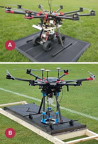
A pothole problem-solver, and its 3D-printing patching ally. Image credit The Self-Repairing Cities Project via American Society of Mechanical Engineers
What’s Cappenin’ This Week
Quick ‘Caps
If you ever thought your sidewalks needed more attention, Arlington, Virginia would commend you...then actually do something about it if they could.
Because their new robots that don’t just walk the walk, they laser the laser.
The city’s bold new urban reality capture experiment features Kiwibots. These county-branded, dare we say cute droids are embarking on a twenty-day mission to survey 45 miles of sidewalks, in what could be the most high-tech sidewalk assessment outside of a robotic Forrest Gump sci-fi reimagining.
I just, felt, like, scanning.
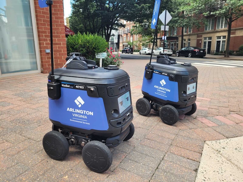
Their primary directive: find and record every crack, weed, and hazardous dip greater than half an inch - which shouldn’t be too tall of an order, as the Kiwibots’ technical setup is unabashedly state-of-the-art. Each is outfitted with a LiDAR array to map surfaces and edges with sub-centimeter detail. Onboard AI, running what’s described as a “DeepWalk” module, sorts through spatial information in real time, distinguishing mere quirks from actionable sidewalk flaws. This deep learning approach turns a basic sidewalk sweep into an autonomous, standards-driven inspection and gold standard of preventative maintenance.
To top off this technological parade, the robots are designed for public visibility and engagement. With animated faces that can turn into hearts and winks, and clear Arlington branding, they’re more likely to elicit a selfie than a security call.
Linked below is ARLnow’s profile of the experiment, the Kiwibot company, why this is a second effort of a failed previous one, visual sensors and GPS, cloud integration, a daring 2028 digital twin vision.
Why drive by your dream house when you could soar around it from your toilet? What is it, 1926?
That’s the pitch - okay, our pitch - behind Zillow’s latest flashy feature: SkyTour, a 3D home touring experience that puts buyers in the virtual cockpit. Leveraging drone footage and powered by Gaussian splatting, SkyTour lets prospective buyers digitally “fly” around Showcase listings, freely exploring lot shape, landscaping, and neighborhood context…from phone or computer.

Realtors may have the worst house on the block, but now at least they can have the best 3D model. Image credit Zillow via GeekWire
Drones systematically circle each home, capturing immaculate video and imagery sequences later processed with Gaussian splatting. The result is a seamless cloud of color and depth - no intrusive geometry or flat panoramas. SkyTour’s splatts present a remarkably immersive, spatially coherent exterior, allowing buyers not just to observe the house but to understand lot lines, landscaping, neighboring context, and nuanced angles that never appear on floorplans or static photography.
This launch is the clear centerpiece in Zillow’s summer suite of upgrades. But for reality capture professionals, SkyTour’s drone-sourced, splatting-powered tours represent a decisive shift: standardized, scalable, up-to-date exterior 3D for residential property at national scale.
As online house hunting becomes the homebuying default, Zillow’s gamble is that high-fidelity, explorable exteriors will become an industry baseline, making “fly-by” the new first impression. GeekWire has some brief analysis linked below, separate from the Zillow press release that details additional, non-reality capture tools.
Out where the Joshua trees watch over sun-scorched Nevada hills that could easily pass for that red planet where Matt Damon grew pooptatoes, the U.S. Geological Survey and NASA’s mineral mappers have set up shop. Only, this time, their sights are locked on Earth’s treasure just beneath our boots.
Armed with tech honed while mapping lunar water and Saturn’s moons, the team is scouring the American West for the critical minerals that underpin everything from smartphones and satellites, to medicine, and which the U.S. currently imports in precarious quantities.
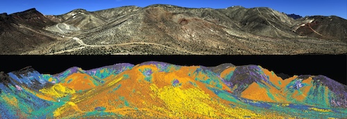
When imaged spectroscopically, Nevada hills glisten with minerals the human eye wouldn’t catch. Image credit USGS/Ray Kokaly via NASA
To obtain the lithium and rare earths, the USGS and NASA opted for the most ambitious airborne spectroscopic survey in U.S. history, the GEMx (Geological Earth Mapping Experiment). Their aircraft, cruising twice as high as commercial jets, carry the AVIRIS-Classic spectrometer (legendary for its tour of planetary duty) and its next-generation successor, AVIRIS-5, capable of detecting mineral fingerprints at scales from 30 feet down to barely a foot, a rainbow-hued leap in subsurface insight. These sensors read the planet in over 200 channels of visible and infrared light, revealing the molecular patterns that make each rock unique. Think, like…nature’s barcode, scanned at altitude.
The effort draws on the legacy of Apollo, lunar boot camps, and the decades-long NASA–USGS partnership, now as vital on Earth as it’s been everywhere else in the solar system.
NASA delineates the project below in a six-minute read on GEMx’s current flight hours and charted kilometers, America’s resource status, the birth of imaging spectroscopy, high-res mineral maps, and the mineral history of Nevada. Oh, and be sure to peek this 20-second GEMx spectroscopy animation.
What is absent in much of the incessant AI discourse is nuance.
According to the bulk of the attention economy, on whatever platform or podcast du jour, AI is either going to be A) Satanic Skynet, or B) the printing press, hand-washing, flight, and the computer combined.
Which is why a recent opinion piece on GIM International, by VP of Reality Capture Software at Hexagon’s Geosystems division Gilles Monnier, is as refreshing as it is engrossing. “Why AI in reality capture does less than you think – but matters more than you realize” is a stampede of data & anecdotes, current analysis & future projection, and fear & optimism.
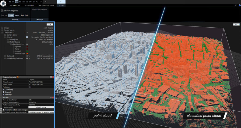
RealityCapture’s AI-classifier tool, an exemplary development of AI’s prowess. Image credit RealityCapture
The article argues that, despite industry fervor, AI’s real impact in reality capture is currently subtle and highly targeted. Rather than universal automation, the technology excels at focused tasks: refining point clouds, classifying objects, cleaning data, and filling specific workflow gaps. These AI-driven improvements may sound modest, but as the piece notes, they’re already making daily processes more efficient and consistent across surveying and geospatial.
What’s especially interesting, the article points out, is that off-the-shelf AI isn’t a silver bullet. Its effectiveness hangs on carefully curated training data and expert oversight, with skilled humans needed on the loop for both QA and judgment calls. Surveyors aren’t being replaced, but rather empowered with smarter, more responsive tools. The future of AI in this space, Monnier predicts, is smaller and more specialized: not monolithic solutions, but a “toolkit” of nimble models that handle niche problems at scale.
Treat yourself to the sweeping read below, also expounding the growing role of completing “incomplete” data, visualization, job loss prospects, survey & surveys of people, smaller-but-smarter, and research & development.
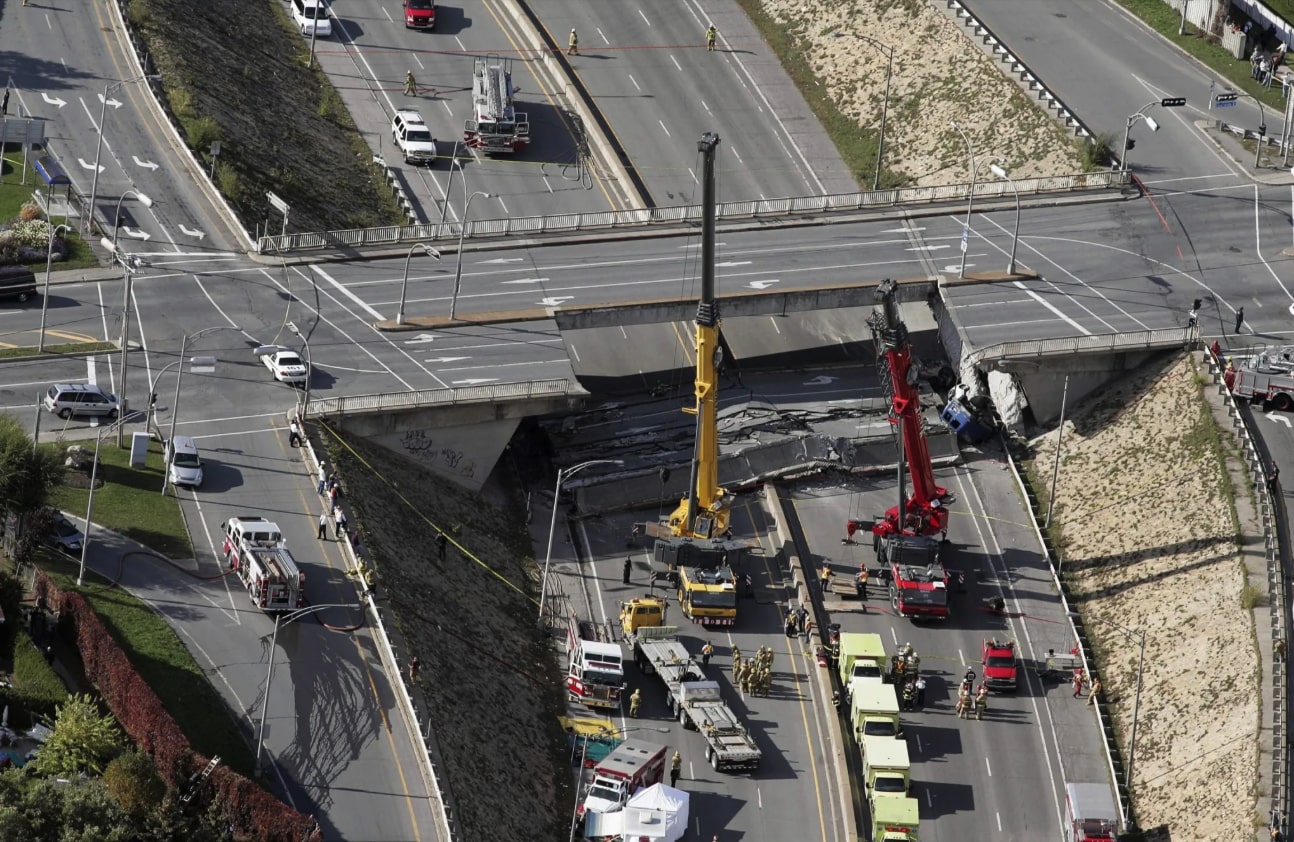
The 2006 collapse of the De la Concorde overpass onto Highway 19 in Laval, Canada. Image credit The Canadian Press/Montreal Gazette
Canada’s built legacy is usually defined by resilience: bridges that span wild rivers, highways that traverse the great shield of rock and snow, and cities where engineering stultifies the cold. But in September 2006, the collapse of Highway 19’s De la Concorde overpass in Laval, Quebec, delivered a stark reminder that infrastructure, no matter how routine or familiar, demands our vigilant respect.
The overpass, completed in 1971, was a product of its era - a time when expansion was urgent, standards were evolving, and the rush of progress sometimes jettisoned details. Beneath a workaday stretch of road, critical design and construction decisions set the stage for disaster decades later. The bridge’s main reinforcing steel was concentrated in a single horizontal plane - a vulnerability that would, over time, invite a critical shear failure. That vulnerability was compounded by misplacement and poor installation of the rebar: a lapse in oversight and execution that took years to manifest but could not be undone.
Materials, too, conspired against the structure. The concrete itself, insufficient in quality and resilience, succumbed to the punishing cycle of Canadian winters, salt, and moisture. Cracks spread, water infiltrated, and the steel within began to corrode. In 1992, a major repair was intended to strengthen the structure. Instead, it further weakened the abutment joint by removing protective concrete without properly restoring strength - a classic case where intervention, absent a full understanding of the underlying problems, led the structure further down a dangerous path.
Warning signs multiplied. Motorists reported falling chunks of concrete and visible cracks well before 2006. The pattern, however, was one of incremental responses: cursory visual inspections, hand-written notes, deferred detailed assessments. Even just before the collapse, urgent complaints from the public led to a site visit, but no closure; a more thorough inspection was scheduled, but disaster arrived first.
The loss of five lives and injury that followed was preventable. The Johnson Commission, tasked with understanding the tragedy, was clear: this wasn’t a single mistake but a “chain of causes” - design vulnerabilities, construction errors, material failings, and most crucially, missed opportunities for decisive intervention.
If there is a single lesson the De la Concorde overpass tragedy presses into the collective memory of Canadian infrastructure, it’s this: we can only fix what we can see, and some dangers remain hidden until they become irreversible. Reality capture and its digital kin offer an unprecedented opportunity to pierce that veil - to turn unspoken warning signs into actionable knowledge and, ultimately, stop disaster in its tracks.
Imagine a world where terrestrial and aerial LiDAR combed the concrete beams of De la Concorde yearly, collecting millions of data points so precise they could spot a hairline crack forming before even the spring thaw could get to work. Instead of a pencil-sketched inspection form filed away in a drawer, engineers would access a digital twin: a living, breathing 3D model updating with every scan, showing every new fissure, every imperceptible sag - data not based on hope, but evidence.
Drones armed with photogrammetry payloads could have swept under and over the spans, mapping surfaces that no bucket truck could reach. With routine drone patrols, even the most inaccessible joint would be documented in immersive 360-degree imagery, compared against last month’s model, revealing the story concrete tries very hard not to tell. IoT sensors embedded inside the deck, reporting temperature, humidity, micro-vibrations, and even chloride levels, would turn the bridge itself into a vigilant sentinel - flagging the start of rebar corrosion, water intrusion, or those telltale freeze-thaw cycles with the immediacy of a breaking news alert.
And then there’s the power of predictive analytics: AI-driven software digesting all this input, cross-referencing it against material science models, and alerting a maintenance team. Is that crack growing with every January freeze and April thaw? Will that rebar’s micro-movement become tomorrow’s tragedy? Modern monitoring answers “what’s happening?” then advances to “when will it become dangerous?”
But even data this rich can’t save lives if it isn’t seen, understood, and acted upon in time. That’s where XR & VR enter the equation. Immersive walkthroughs of the bridge could have placed inspectors and decision-makers inside the structure, highlighting deterioration not as abstract data points, but as visceral, navigable environments. Subtle sags or cracks might become unmistakable when experienced at full scale, with spatial context, in a way flat images never could. Simulations inside VR could have modeled worst-case load scenarios and shown how minor damage today might lead to catastrophic failure tomorrow. Augmented reality overlays in the field could guide repair crews to exact points of concern, while collaborative VR sessions could have united stakeholders across agencies, transforming disconnected reports into a shared, urgent understanding
For De la Concorde, the difference is not just more data: it’s the hard line between knowing and not knowing, between preservation and catastrophe. In a world now overflowing with digital senses, there’s little excuse left for letting a bridge’s warning signs slip quietly away. For all the poetry of Canadian winters and the resilience of our infrastructure, it’s technology - sharp-eyed and tireless - that offers our best hope to be consistently anti-error.


By subscribing, you are agreeing to RCN’s Terms and Conditions of Use. To learn how RCN collects, uses, shares, and protects your personal data, please see RCN’s Privacy Policy.
Reality Capture Network • Copyright 2025 • All rights reserved


