CTRL+V Re/Cappers, it’s a digital twinsday, as a staggering update has been announced from the European nation that, years ago, sought to Doppelgäng (HINT!) itself.
But there are levels, people! You don’t go from Ella Fitzgerald to Megan Thee Stallion without some sort of gradation. So if there’s a country that wants to twin itself now, surely a predecessor would be a city, yeah?
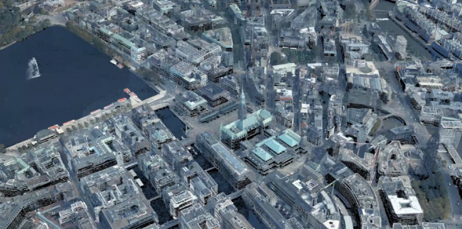
Willkommen, to Zurich, Switzerland's digital twin; a 20-year odyssey that reads like sci-fi but packs the real-world precision of a Swiss timepiece.
Nearly two decades ago, Zurich's city planners faced a modern problem; their traditional maps, those trusty flat companions that had guided urban development for centuries, had become as useful as a sundial in a thunderstorm. The city was growing vertically and conceptually: solar panels needed sunlight calculations, flood models required elevation data, and citizens increasingly demanded to peek behind the bureaucratic curtain of urban planning. They needed better maps, yes - but right alongside a crystal ball.
The GIS City of Zurich team approached this challenge with characteristic pragmatism. Rather than starting from scratch (heaven forbid), they began building upon their existing spatial data infrastructure, eventually creating a high-res 3D model consisting of a terrain model, an urban block model, and a roof model, sourced from LiDAR and cadastral surveys.
The transformation was more tortoise than hare, a methodical evolution from simple 2D mapping into something that would make SimCity developers weep with envy. Using 3D scanning, photogrammetry, and aggressive cadastral surveys, they began constructing a digital duplicate of their beloved city.
The beauty of this approach was in its comprehensiveness. While other cities were still debating the merits of 3D modeling, Zurich had already corralled 25 city service departments into this grand experiment. Imagine the meetings; traffic engineers arguing with environmental scientists, while urban planners mediated like diplomatic referees in the Municipal MMA League.
Perhaps most remarkably, Zurich committed to something that would make their traditionally secretive banking sector nervous: radical transparency. The city made their data sets available as open government data, essentially handing citizens the keys to their digital kingdom and demonstrating confidence in democratic participation.
Zurich's twin ascended to technological Matterhorn status. The system now runs climate scenario simulations with the dedication of a meteorologist on espresso. It calculates solar potential for every rooftop, models noise propagation (crucial in any well-ordered city where quiet hours matter), showcases architectural competition through AR, and simulates flood patterns with impressive precision.
The success of Zurich's digital twin represents more than achievement & audacity; it illustrates the power of silo destruction, of different departments sharing information, and making decisions based on evidence rather than tradition or interdepartmental politics. In government terms, this is the stuff of miracles.
It also stands as a testament to methodical engineering: start with a real problem, apply systematic thinking, involve stakeholders at every level, and build something that works reliably for decades…and inspires the world to follow suit.
What’s Cappenin’ This Week
Quick ‘Caps
The Re/Cap Podcast: The Survey Saga of a Legendary Texas Cave
When a nation exemplifies dreaming big - the autobahn, copious capital letters, drinking beer out of glass boots so large Andre the Giant would ask for tightened laces - it’s no surprise it would aim for the stars in modern infrastructural tacklings.
But for Germany, it seems as easy as if they were aiming for the nearest schnitzel joint.
It started in 2022, when the Federal Agency for Cartography and Geodesy (BKG) unveiled Digital Twin Germany. Its vision was entire coverage by December of 2026, and Holy Deutschland are they on pace!
Hamburg (and its City Hall, at center) was the guinea pig for Digital Twin Germany. More like Scanburg! Image credit GIM International
DTG relies on a high-precision 3D model born of advanced airborne laser scanning. Now, because we’re talking about, you know, an entire freaking country as opposed to a warehouse, DTG needs Geiger-mode or single-photon LiDAR (GmL/SPL) rather than the conventional sort. These balance extensive area coverage with the high resolution needed for rapid, efficient topological nationwide surveying. Both methods do still use time-of-flight measurement.
Once complete - and that is no sure thing given the need for amenable weather - DTG will be updated every three years, helping remedy serious questions: Where will the next flood spill over? Which regions are most heatwave-sensitive? Is that wind farm idea brilliant or bonkers? It’s an AI-rich smart policy tool, risk‑management crystal ball, and bellwether of Industry 4.0.
GIM International sheds light below with an update on the original 2022 unveiling (check the Hamburg pilot project!), paying special attention to the applications, smart country traits, and potential effects on policymaking.
In Hinduism, the deity Shiva represents opposites: destruction & transformation, indulgence & abstinence, wrath & benevolence.
So it’s only fitting that a collection of ancient temples dedicated to Shiva be at once old…and starkly modern.
This is the UNESCO Heritage Site known as the Elephanta Caves, a stone’s throw from Mumbai. Carved from basalt ~1500 years ago, they’re masterpieces of devotion and craftsmanship, having endured monsoons and invasions while hosting centuries of silent prayer. But recently, deterioration has accelerated on account of tourism, environmental pressure, and the implacable forces of time.
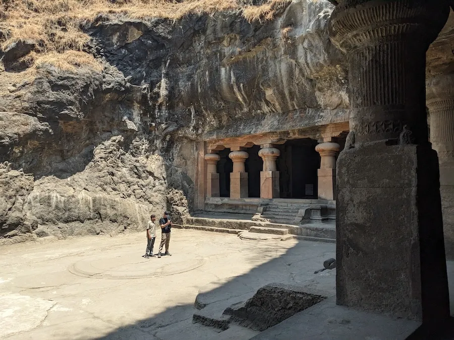
Project planning at the entrance to the Elephanta Caves! Image credit CyArk via LiDAR News
Welp, from destruction, comes creation.
CyArk, alongside the INSTUCEN Trust (India Study Centre), Iron Mountain, the Archaeological Survey of India, and Google Arts & Culture, has chronicled every curve, every chisel mark, every homage with LiDAR scans, photogrammetry, and even local expertise - all woven into a story one can explore without boarding a Mumbai-bound boat.
The result? A global gateway, an open-access 3D model and guided virtual tour that lets you wander sacred interiors from anywhere on Earth. LiDAR News covered the multi-party procedure below, from narration to student scanning training, in a glorious exhibit of innovation as a saving grace.
Next time someone tells you laser scanning is a fad, you can tell them “Nuh uh, it’s a Fahd”.
Saudi Arabia’s King Fahd Stadium is approaching its 40th birthday in 2027. But 2034 is the real cause for celebration…and renovation. As the site for that year’s World Cup, the iconic Bedouin tent–shaped stadium is aiming to stretch its seating from 60,000 to 80,000. But, oh no! The only blueprints were charmingly ancient hand-drawn plans from the '80s.
So, how do you digitize an entertainment mecca with sketchy old maps? You scan, with more fervor than a keeper scanning the pitch.
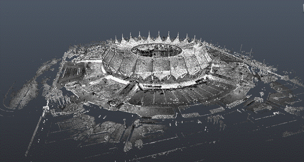
The whole exterior took just five days! Image credit Leica Geosystems
Writing as a guest author on Geo Week News, Leica’s Nathan Savory detailed the gargantuan undertaking, and how the BIM maestros of Inisys were instrumental. The team unleashed an arsenal of terrestrial laser scanners for 4,700(!) sessions over just five weeks. Drones were no-no’d due to a nearby air force base, so the scanners had to work their magic from the ground, capturing details from the highest points of the enormous roof to the most hidden corners of the MEP systems nestled in ceiling cavities and gymnasiums.
Accuracy was king; the structural joints had to be modeled within 6 millimeters, and architectural elements within 25 millimeters, all while adhering to ISO 19650 standards.
Get the full scoop below, with additional coverage on interior complexity & control points, scanning & coordination around live matches, hardware and software, scaffolding use, the final BIM model, and more.
Two floors…$100 - $130k just, in, rework.
That was the ghastly tab that confronted a Memphis glazing contractor, JR Butler, as part of its 15-story St. Jude Medical center expansion project. And it all stemmed from inaccurate data, the nucleus to a delightful new piece on Engineering News-Record by Jeff Yoders, Associate Technology, Equipment and Products Editor.
Despite surveying being the foundational step for myriad projects, it remains frustratingly prone to human error, with misaligned control points regularly transforming well-coordinated 3D models into expensive puzzles.
Yoders’ “In Surveying, Small Wins Bring Big Gains” reveals how to many veterans, for this dilemma, surveying is more art than science. It chronicles humanity's struggle against imprecise measurement, where a misplaced chalk line can send entire projects into crisis.
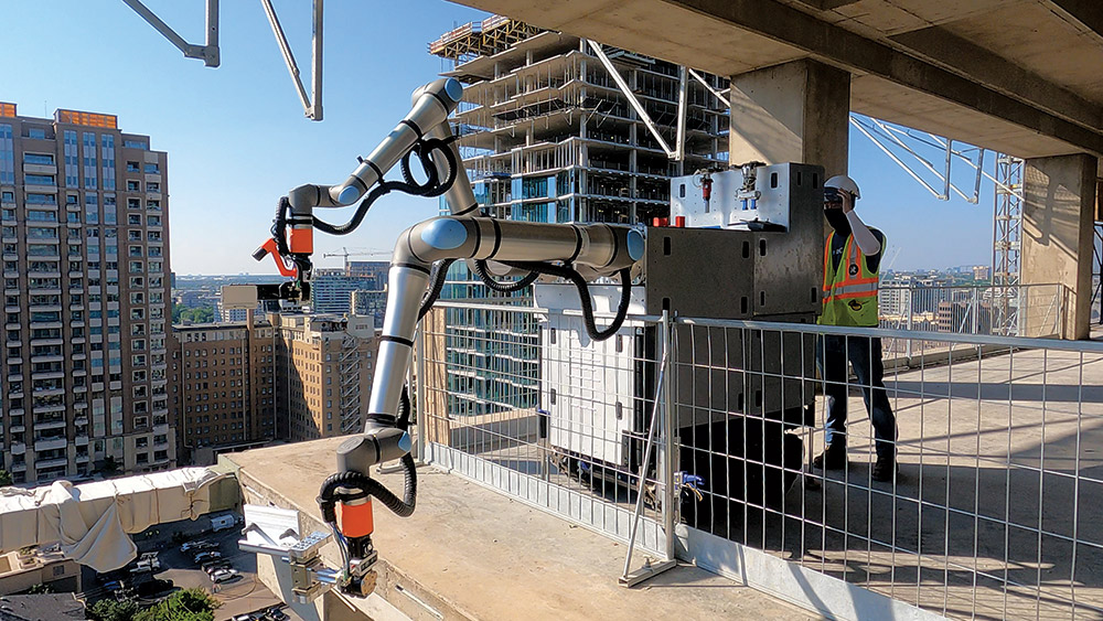
Allergic to rework, Raise Robotics’ onboard sensors are to accurate floor layouts what football season is to snacks. Image credit JR Butler/Raise Robotics via ENR
The central revelation is charmingly paradoxical: in an industry obsessed with megaprojects, salvation comes from perfecting the mundane task of baby-problem-solving and figuring out where things actually…are. As one contractor wisely notes, true innovation sometimes means fixing "the things you least expect, that you pay the least amount of time and money to, but always have the same problems."
Take in the exquisite case study-heavy piece on getting granular, robotics & floor layouts, the upcoming longest & deepest road tunnel in the world, and a goldmine of stakeholder and technologist wisdom.
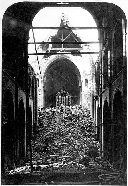
Chichester Cathedral Spire, 1861. Image credit Historic England Archive
For 461 years, the soaring spire of Chichester Cathedral had defied gravity, weather, and war. Added in 1400 to crown the Norman cathedral, this Gothic masterpiece rose 277 feet into the Sussex sky, a testament to medieval engineering prowess that had survived fires ad nauseum, lightning strikes, civil war bombardments, and the great storm of 1703. The spire was a beacon visible for miles across the South Downs, guiding sailors home from the English Channel and pilgrims to one of England's most sacred spaces.
But by the winter of 1861, this stone sentinel was living on borrowed time. Centuries of subsidence had been quietly undermining its foundations, while weather, thermal cycling, and simple gravity had worked microscopic changes in the medieval masonry. The cathedral sat on treacherous ground that had already claimed victims of two facade towers collapsing in 1210 and 1635 due to persistent subsidence issues. Mortar joints had weakened, stones had shifted imperceptibly, and load paths that had carried the spire's weight for four and a half centuries were showing their age.
The final act began with a single, seemingly innocuous decision in 1860: the removal of the wooden Arundel Screen that divided the nave from the choir. What the Victorian cathedral authorities saw as an outdated liturgical barrier, medieval engineers had designed as a crucial structural element, the final piece of a load-bearing system that had been quietly compensating for centuries of gradual structural deterioration.
Within months of the screen's removal, cracks as long as 5 feet began snaking across the cathedral's fabric. The building's stone skeleton could no longer bear loads it had for centuries. The screen, dismissed as mere decoration, had been the last critical brace holding together a structure already weakened by time and geological betrayal.
On February 21, 1861, just over a year after the screen removal, the inevitable happened. Witnesses described the spire seeming to pause, as if considering its options, before inclining slightly to the southwest. Then, in what observers called an almost graceful motion, the entire 200-foot structure descended perpendicularly into the church below. 461 years of medieval craftsmanship telescoped down in second, largely due to one fateful decision.
In 1861, the spire’s only monitoring system was a “trained” eye possibly five pints deep battling some mystery malady. Today, the spire would not have gone quietly. Before a single stone shifted, high-precision metrology and laser scans taken year after year would have whispered its secrets: minute tilts, creeping misalignments, the telltale sag of a structure fighting gravity on uneven ground. Photogrammetry from drones sweeping the spire’s height could have traced hairline cracks as they formed, their paths mapping the building’s slow negotiation with subsidence.
A sensor & AI combo trained on years of structural health data could have spotted the spire’s growing dependency on the Arundel Screen long before the Victorians reached for their crowbars. Every sensor reading, every crack measurement, every tilt detection would have automatically updated the cathedral's BIM model in real-time, creating a living architectural intelligence that understood not just what the building looked like, but how every stone, joint, and buttress performed under stress. And inspection wouldn’t merely live in data tables; through AR, a mason walking the triforium could see the spire’s BIM twin ghosted over the real stonework, cracks glowing like fault lines in red, tilts outlined in ghostly wireframes. The invisible would lose its “in”.
All of it could have fed into a living digital twin, a cathedral in pixels that flinches when the real one does. A quick simulation of “screen removal” would have played out like a disaster film: support gone, stresses spiking, collapse inevitable.
Reality capture wouldn’t have waited for February 21, 1861, to make its point. It would have stood in the nave, pointed to the screen, and said, “You might want to leave that exactly where it is.”


By subscribing, you are agreeing to RCN’s Terms and Conditions of Use. To learn how RCN collects, uses, shares, and protects your personal data, please see RCN’s Privacy Policy.
Reality Capture Network • Copyright 2025 • All rights reserved