
Frown → upside down Re/Cappers, today’s lead ‘Cap is an uplifting tale of a man whose love of aquatic photogrammetric surveys is so strong, even paralysis is but an oyster-sized annoyance for his fortitude.
This PhD candidate is advancing ROVs (remote operated vehicles) in a way that would thrill the Zeus of deep sea archaeology, surveying, and imaging.
That be George Fletcher Bass (1932–2021), the father of nautical archaeology who dared to bring surveying and photogrammetric thinking into the vessel-claiming abyss.
In 1960, while still a PhD student at the University of Pennsylvania, Bass was invited to Turkey to help excavate a Late Bronze Age wreck off Cape Gelidonya. At the time, shipwrecks were treated more like maritime easter egg hunts than hallowed archaeological sites. Divers hauled up artifacts with total regard for booty and little for context, leaving scholars to hypothesize the story of a ship and its cargo.
Bass, in an early showing of his patented independence, insisted on doing things differently. He took the careful methods of land archaeology like grids, measurements, and stratigraphy, and transplanted them to the seafloor. Divers laid out baselines and plane tables, sketched artifacts in place, and took systematic photographs that could be pieced together(!) later. It was the first time a shipwreck had been excavated to true archaeological standards.
Bass’s next decades were spent advancing the technology of recording. He encouraged divers to take overlapping photographs so that site plans could be assembled into photo mosaics, a preamble to what would become modern photogrammetry. In 1963, he secured the submersible Asherah, the first American-built submarine intended for archaeology. Bass outfitted it with stereo cameras and side-scan sonar, experimenting with three-dimensional mapping techniques at depths beyond safe diving limits.
At Yassi Ada, Byzantine wrecks were mapped with uncanny detail. At Uluburun, one of the richest and earliest Bronze Age wrecks ever discovered, teams relied on photogrammetric recording to document the intricate arrangement of cargo before it was removed. Even his seemingly simple innovations, such as using air lifts to move sediment carefully rather than destructively, reflected his larger goal: to create an accurate, measurable record of sites in situ. What had once been guesswork became survey. What had once been sketches became photography. What had once been 2D notes became the origins of 3D recording.
Bass even turned his personal vision into an institution. He founded the Institute of Nautical Archaeology in 1972, and a few years later INA partnered with Texas A&M University to launch the world’s first graduate program in nautical archaeology. Generations of students learned to dive, but also how to survey, document, and map wrecks with the same rigor expected on land. Their projects carried Bass’ ethos forward: archaeology was less about salvage and more about context, and context depended on precise documentation.
Bass’ legacy was a leviathan. He argued tirelessly for the preservation of wrecks against treasure hunters, influencing legislation and international policy. He won archaeology’s highest honors, including the National Medal of Science in 2001. But perhaps his greatest achievement was methodological. He proved that the ocean floor could be treated as a measurable, mappable space, where unerring survey was as valuable as recovery.
From the first grids he laid on the seabed to the stereo photographs taken from Asherah, Bass was a maverick. Beneath the waves, long before “reality capture” became a term that docked in modern vernacular, Bass had already set its course.
And it keeps sailing, as we’ll see shortly.

The discovery & 10-year excavation/imaging of the Uluburun shipwreck. Image credit Biblical Archaeology
What’s Cappenin’ This Week
Quick ‘Caps
You know it’s an inextricable bind to exploration and technology, when this is a realization seconds after a paralyzing ski accident; “When I was lying there on the mountain, one of my first thoughts was that I may never go to sea and fly an ROV again.”
Nothing could have been more plausible than for that fateful Maine day to stop Jake Bonney; from piloting ROVs (remote operated vehicles), underwater surveying, and his doctoral work…
Feh! A man of as much defiance as passion, he’d have none of it!

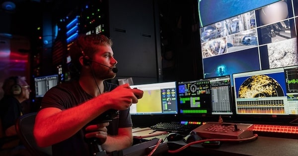
Remote underwater surveyor extraordinaire, Jake Bonney. Image credit Ocean Exploration Trust via ECO Magazine
During his PT in a hospital, Bonney participated in a vast shipwreck survey in Lake Ontario by piloting the ROV “Rhody” entirely remotely; a breakthrough for both accessibility and maritime survey work. A highlight was completing a photogrammetry survey of the steamship Iona, sunk in 1912.
Bonney flew the compact ROV to maneuver through tight shipwreck features, systematically capturing multiple angles for exhaustive 3D modeling. Real-time ‘grammetry model displays from Voyis cameras onboard the ROV provided immediate feedback, enabling him to adjust capture strategies and ensure high-res, accurate reconstructions.
Environmental, Coastal, & Offshore magazine reaches the depths of the astonishing perseverance tale; click below for an analysis of that real-time underwater photogrammetry model, Jake’s lessons from his naval architect dad, ocean engineering PhDs, the Ocean Exploration Trust and Ocean Exploration Cooperative, medical & physical obstacles, and how Jake seeks to improve the practice of remote piloting.
Moʻolelo. Now there's a word that carries the weight of islands.
It’s Hawaiian, a kind of amalgam of story/myth/history/fable/tradition, and so forth.
It’s also the motivation behind three University of Hawai’i fellows’ heroic harnessing of advanced tech, to preserve and protect their nation’s treasured coastlines.

L to R Hawaiian coastal heroes Maile Hoe, Joey Wu and Olivia Boucher! Image credit University of Hawai’i
We’re talking drones. VR. 3D printing. Gleaning intel from indigenous moʻolelo. More mapping ideas than Hiltons in Honolulu.
It was all wielded deftly by the trio above, thanks to the Resilient and Sustainable Coasts Fellowship, an eight-week paid program from the University of Hawaiʻi Sea Grant College Program.
University of Hawaiʻi News gave flowers to each student fellow, exploring the historical advocate responsible for the fellowship’s start, pressing coastal challenges, cross-sector collaboration, VR as stewardship, UAS for land & shallow-water elevation data, how to approach research questions, and more.
Romania’s Buzău County has been a magnet for tourists, as it’s home to a carnival of nature-belching. Its Mud Volcanoes have long been putting on quite the airy show, bubbling, burping, and releasing mysterious gases from the earth below. But despite all the attention from visitors, scientists have largely ignored this geo-spectacle. Until now.
Armed with an impressive arsenal of drones and reality capture gear equipment, Romanian scientists have finally decided to give these muddy marvels the scientific attention they deserve.

The sprawl - and rare non-extreme mess - of Romania’s Mud Volcanoes! Image credit Romania Insider
The team from Romania's National Institute for Earth Physics Research and Development recently deployed drones loaded with LiDAR, ground-penetrating radar, magnetometers, thermal cameras, and gas sensors. The partnership with Skyline Drones and SPH Engineering seeks to crack the code of unstable terrain, track those telltale gas emissions, and pinpoint exactly where the ground might decide to take an unexpected tumble.
Of particular intrigue is that, despite drawing tourists eager to witness nature's own mud show, these geological gems have been surprisingly neglected by the scientific community. Yet the project trained the next generation of researchers in novel geophysical and aerial survey techniques, while generating fresh data that could prove invaluable for both education and disaster prevention. The implications stretch far beyond Romania, as they could revolutionize how we approach geological hazards worldwide.
Building on 2024’s 3D subsurface mapping success with FullWaver equipment, this drone mission’s got no muddy waters thanks to Romania Insider - article linked below.
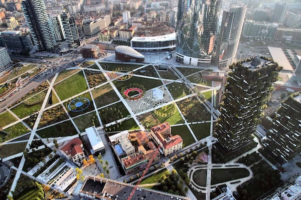
Milan's Porta Nuova district is what happens when urban planners discover that buildings can be taught to think; a once-derelict rail yard transformed into Europe's most ambitious experiment in making concrete intellectually curious. Its buildings are the Mediterranean diet for energy, cutting use by 75% while avoiding over 2,200 tons of annual CO2 emissions.
Such rejuvenation is the catalyst for a sweeping dissertation on Engineering.com, "How Software is Redefining Sustainable Building Engineering."

Milan, Italy’s Porto Nuova district, once a ramshackle railyard. Choo choo to innovation! Image credit The Plan
The piece reveals a paradox at the heart of our smart building revolution: we're drowning in data while thirsting for insight. Building owners collect tsunamis of information about energy patterns, occupancy flows, and maintenance needs, then either ignore it or grow befuddled by it. Then ya got engineers’ identity crises, suddenly required to master everything from cybersecurity to AI-driven controls, as if buildings decided overnight to become giant, temperamental computers with exorbitant heating bills.
Below is the brilliant read on teaching century-old buildings new tricks while avoiding vendor lock-in, lack of data vs. lack of interpretation, engineer empowerment, privacy, shifting stakeholder expectations & communication, and more. Plus, a deluge of quotes from executives whose badges read Siemens, MIT, VP of Digital Energy, and beyond.

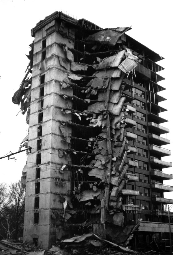
The 1971 collapse of Boston’s 2000 Commonwealth Avenue. Image credit Simpson Gumpertz & Heger
The morning of January 25, 1971, dawned frigid over Boston's Brighton neighborhood, where workers at 2000 Commonwealth Avenue moved with practiced urgency sixteen stories above the street. By nightfall, this luxury condominium tower would become a monument to hubris, with its eastern two-thirds collapsed into rubble.
The building had risen through a cascade of compromises: incomplete permits, sporadic inspections, and quality control that existed more in theory than practice. Cold weather and poor site conditions had weakened the concrete. Formwork was removed prematurely, forcing the young structure to bear loads it wasn't ready to shoulder. As workers poured fresh concrete on the mechanical penthouse that morning, invisible stresses concentrated around a single column connection below - inadequate shoring, premature loading, and insufficient concrete strength creating a perfect storm of structural vulnerability.
What followed unfolded with terrible patience. Around mid-morning, the roof slab began to sag, concrete straining against forces it could not contain. For nearly twenty minutes, the building telegraphed its distress, with deflections and cracks becoming visible. The structure was begging for rescue, but in the noise of an active construction site, the subtle language of structural failure went unheeded. Then physics asserted its dominance: punching shear around the critical column triggered a progressive collapse that moved floor by floor with deliberate, terrifying rhythm.
The collapse was triggered by a punching shear failure at a key column slab on the roof, compounded by myriad shortcomings. Critical deficiencies included missing shoring beneath the roof slab, insufficient concrete strength - as low as 700 psi, well below the specified 3,000 psi - and overloaded loads from freshly placed concrete and stored equipment. Poor placement and insufficient length of reinforcing bars, premature removal of formwork, and a near-total lack of proper field inspection and construction control further weakened the structure. These design and construction flaws led to the progressive collapse of two-thirds of the 16-story building, tragically killing four workers and injuring 20 others.
When the roof slab began its fatal sag that January morning, twenty minutes of visible distress preceded catastrophe. In today's world of reality capture, those twenty minutes would have been twenty minutes too late - the warnings could have started the moment geometry began to betray design intent.
Aerial or terrestrial laser scanning creates a precise geometric structural fingerprint, and could have monitored the punching shear zone around that fatal roof column, detecting microscopic deflections in the slab that preceded visible sagging. Regular scans comparing actual geometry against design intent would have flagged the inadequate shoring and premature concrete loading, pre-catastrophe. Analysis of point cloud data, potentially augmented by AI, could identify the telltale deformation patterns that precede punching shear failure; subtle dish-shaped deflections around column heads that human eyes miss until it's too late.
All of this could have fed into a digital twin that updates with every scan, creating a living model of structural behavior under changing conditions. Instead of relying on sporadic inspections and visual assessment, project teams work with continuous, objective monitoring that flags dangerous deviations.
Yes, technology can capture reality. But in instances like these, tech forces us to confront it. Those four workers died because speed was chosen over certainty, assumptions over evidence. Think that’s not a problem today?
Every scan that goes untaken, every warning that goes unheeded, every shortcut that masquerades as efficiency is a choice to flirt with 1971 all over again. The tools to prevent the next 2000 Commonwealth Avenue exist today. The only question is whether we'll use them, or whether we'll keep building monuments to our own hubris - until the next time physics reminds us that compromise has consequences.


By subscribing, you are agreeing to RCN’s Terms and Conditions of Use. To learn how RCN collects, uses, shares, and protects your personal data, please see RCN’s Privacy Policy.

Reality Capture Network • Copyright 2025 • All rights reserved